Can we trust Cuadrilla’s E-Portal?
After last week’s seismic events a lot of attention focussed on Cuadrilla’s e-portal and the decision they took not to show what they call “trailing events” (i.e. events which occur outside of the times they are actually pumping fluid) with a magnitude less than 0.5. This of course means that their graphs in the “Seismicity in Local Magnitude” tab don’t need to show it as “The Local Magnitude (ML) graph refers to the magnitude of any seismicity detected above 0ML whilst we undertake hydraulic fracturing operations at Preston New Road.” which with casuistry worthy of a 17th century Jesuit priest they narrowly interpret as whilst actually pumping.
If you look at that tab today (Monday 22 October) you would never know the seismic events of last week occurred at all (unless of course you read the national and local press).
The same applies to the “Local Seismicity” tab which cover the last 24 hours, but as far as we could tell didn’t show the 0.3 Ml tremor which occurred on Friday. To be fair to them they do tell you as you enter this section of the portal that “DATA FOR TRAILING EVENTS (EVENTS OUTSIDE THE TIME WE ARE PUMPING) WILL NOT BE SHOWN IF SMALLER THAN 0.5ML.”. Why they have taken that decision is not explained though.
However, what about the “Background Regional Seismicity” map which purports to show “any” seismic activity “in the wider area” which has taken place since November 2017. Strangely, after the weekly update, that is still not showing the 0.3 ml quake although the key clearly suggests that it does show any activity above 0.0 and below 0.5 Ml

This piqued my curiosity so I decided to delve a little deeper.
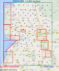
Cuadrilla have plotted 18 seismic events on their map. They are shown below. In 11 of the 18 instances the data shown in the box that appears when you click on the dot has a discrepancy with the BGS data associated with the event. The Cuadrilla data is shown in the right two columns where such a discrepancy is highlighted in red in the main grid. In spite of having a key item for events 0.0-0.5 Ml they have failed to plot any.

The BGS database shows us that in the area covered by England and Wales there have been 121 seismic events recorded since 27th November 2017 with magnitude 0.0 Ml or higher. I have excluded 18 of these as they would appear to be outside the area in which Cuadrilla have chosen to plot their data. These 18 include the cluster of 11 at Newdigate which are presumed to be linked to oil extraction by UKOG is Surrey, so we can see why Cuadrilla might not want to plot quite as far South as that. This leaves us with a total of 103 events of which Cuadrilla have chosen to plot just 18.
A Google Document with the data set is embedded below. It shows that there were 85 seismic events (14 between 0.0 – 0.5 Ml, 59 between 0.5 – 1.5 Ml and 12 >1.5 Ml) which Cuadrilla have failed to plot even though they would appear to have occurred within the area they have plotted data in.
This raises the question of how much we can trust Cuadrilla’s portal to show us accurate and up to date information.
How can they really be claiming to show us “any” seismic activity “in the wider area” and yet only show us a fifth of the data that anybody can find on the BGS database?
And this is apart from the self-selected decision not to show “trailing events” in their other tab.
I have emailed Cuadrilla to ask for an explanation, but I don’t expect a reply as they have already told me that they will not answer any questions I put to them.
Of course none of this may matter shortly as today Lee Rowley MP told the APPG, that the seismic traffic light system may not apply across sites throughout England, only to Lancashire. The gilt is rubbing off what Mark Menzies MP calls our “Gold Standard” regulations faster than they can cause the earthquakes that the regulations are supposed to protect us from!